
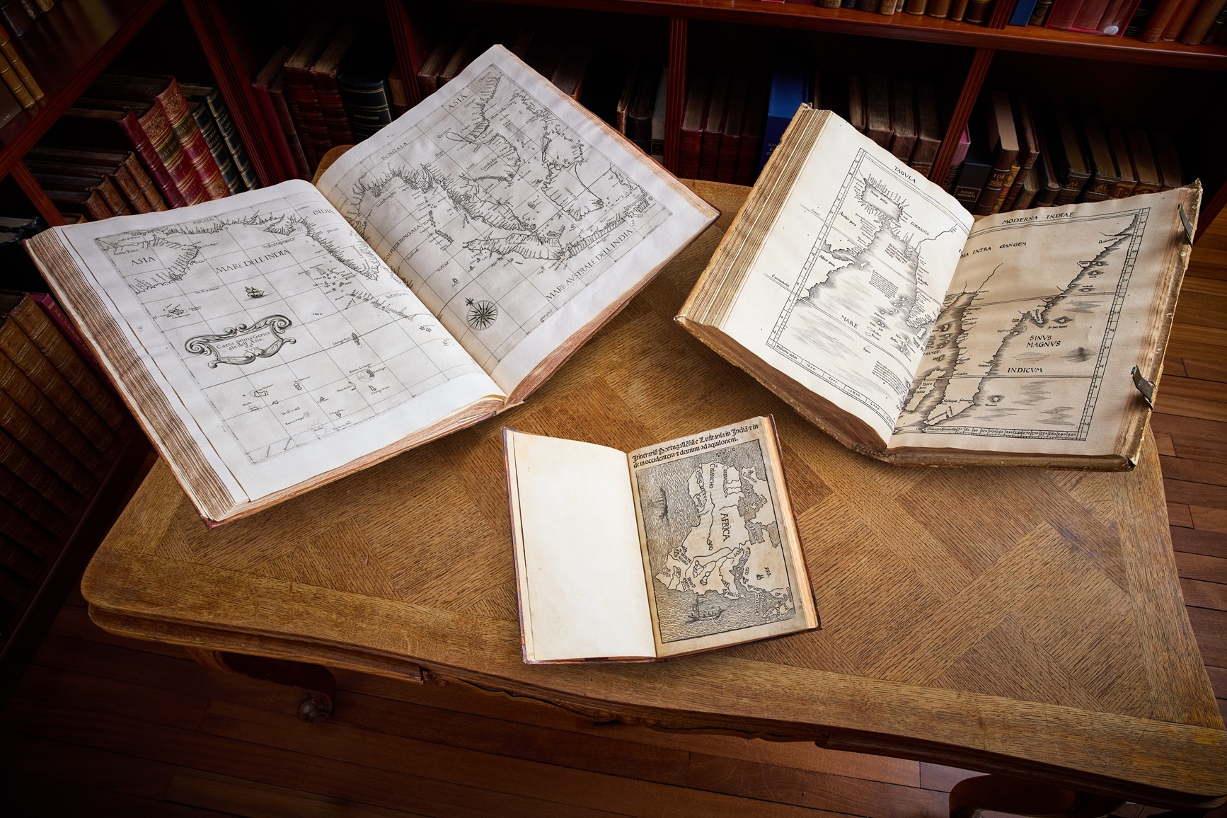
Peter Harrington will present a rare, complete manuscript of Ibn Battuta’s Rihla, a 16th-century Spanish edition of Marco Polo’s travels, and atlases featuring some of the earliest printed maps of the Arabian Peninsula and the Indian Ocean at the inaugural fair.
The curated collection will include a rare complete copy of Ibn Battuta’s Rihla,
a 16th century Spanish edition of Marco Polo’s journeys through Asia, landmark atlases containing the first printed maps of Arabia and the Indian Ocean, and accounts of the Portuguese voyages that revolutionised global commerce.
NOVEMBER 17, 2026, Leading rare book dealer Peter Harrington will present a special collection of rare books, atlases and accounts at Frieze Masters Abu Dhabi 2026, tracing the Indian Ocean’s centuries-old position as a major corridor of global trade. The collection explores the strategic role the Arabian Peninsula has always played in connecting Europe, Africa and Asia.
Spanning ancient maritime accounts, medieval travel narratives, early European exploration and the rise of the great Western trading empires, the exhibition explores how control of the region’s ports and waterways became central to commercial and political power.
Long before European ships reached India, regional merchants had established extensive maritime networks linking the Gulf and Red Sea with East Africa, India and Southeast Asia. The Arabian Peninsula’s position at the crossroads of these routes made it a vital centre of commerce, connecting the lucrative trade in spices, silk, pearls and other commodities with markets further west.
The selection presented as part of the inaugural Frieze Masters Abu Dhabi follows the development of geographical knowledge, from early descriptions of distant lands and medieval travellers’ accounts to increasingly accurate maps and navigational charts. As European powers sought access to these established trading networks, geographical knowledge became valuable commercial intelligence, enabling merchants and competing empires to navigate, trade and assert control over strategically important waterways.
Commenting on the collection, Pom Harrington, owner of Peter Harrington, says:
“The Indian Ocean has been one of the world’s great trading corridors for centuries, and the Arabian Peninsula’s position between Europe and Asia has always given the region enormous strategic importance.
“What makes these books and maps so fascinating is how they chart the growing understanding of these routes as major gateways to international trade, and how that knowledge became a means of gaining commercial and political power. The principal players operating in this region have changed over the centuries, but the geography has remained the same. These extraordinary works offer a historical perspective on why access to these waterways remains so important today.”
The display opens with ancient maritime commerce and the great medieval journeys East, before examining Portuguese expansion into the Indian Ocean, the development of modern cartography and the navigational intelligence that helped the English and Dutch challenge Portuguese dominance. Among the works is de Bry’s richly illustrated Petits Voyages, which includes Gasparo Balbi’s account of the Gulf’s pearl trade and some of the earliest recognisable recorded names of places in the modern UAE, including Dubai, Sharjah and Ajman.
Later sections explore the region’s role in scientific discovery, natural history and British imperial expansion, culminating in the commercial and territorial negotiations that reshaped Southeast Asia during the nineteenth century.
IBN BATTUTA – Tuhfat al-Nuzzar fi ghara’ib al-amsar wa ‘aja’ib al-‘asfar (Rihla). North Africa, 1768 (£350,000)
A rare complete manuscript of Ibn Battuta’s Rihla, one of the most extensive travel narratives of the medieval Islamic world
Beginning with a pilgrimage to Mecca in 1325, Ibn Battuta travelled across Arabia, East Africa, India and Southeast Asia as far as China. His account offers a remarkable first-hand record of the ports, trading communities, courts and daily life of the medieval Indian Ocean world, including the Gulf’s pearl fisheries and the commercial networks linking Arabia with India. Copied in North Africa in 1768, this manuscript preserves the complete, unabridged narrative.
MARCO POLO – Libro de las cosas maravillosas que vido en las partes orientales. Logroño, 1529 (£150,000)
Rare 16th century Spanish edition of Marco Polo’s travels – one of the most influential medieval accounts of Asia.
Polo’s descriptions of bustling ports, Arabian horses, spices, silk, ivory and precious stones reveal the sophisticated commercial networks already operating between Arabia and Asia long before the arrival of European maritime powers.
FRACANZANO DA MONTALBODDO – Itinerarium Portugallensium. Milan, 1508 (£450,000)
Containing the earliest printed account of Vasco da Gama’s voyage to Calicut
The first Latin edition of Montalboddo’s pioneering collection of voyages contains the earliest printed account of Vasco da Gama’s voyage to Calicut (1497–99), which “opened the way for the maritime invasion of the east by Europe” (PMM). The excitement of the discovery is palpable: “all the wealth of the world seems now to have been discovered.”
The book’s remarkable title-page woodcut is among the earliest separately printed maps of Africa, showing the continent’s complete coastline with Arabia, India and a prominently named Calicut beyond it; this copy preserves the first state of the map. The accounts vividly capture the first encounters accompanying the opening of the maritime route to India: Calicut’s merchants and spice trade, Cabral’s subsequent expedition and trading at Cochin and Cannanore, and descriptions of the communities, customs, crops, coinage, shipping and commerce of the Malabar coast.
CLAUDIUS PTOLEMY & MARTIN WALDSEEMÜLLER – Geographia. 1513 (£750,000)
The first modern atlas of the world – Its Tabula Moderna Indiae is considered both the first printed map to feature “modern” Arabia and the first “modern” map of Southeast Asia to reflect Portuguese discoveries
“The most important of all the Ptolemy editions”, this landmark atlas juxtaposes the geography inherited from antiquity with a revolutionary supplement of “new” maps that marked the beginning of modern map-making. Its Tabula Moderna Indiae, drawn from contemporary portolan charts, is considered both the first printed map to feature “modern” Arabia and the first “modern” map of Southeast Asia to reflect Portuguese discoveries. Most significantly, following Vasco da Gama’s voyage, the Indian Ocean is portrayed as open rather than closed as previously thought.
JAN HUYGEN VAN LINSCHOTEN – His Discours of Voyages into ye Easte & West Indies. London, 1598 (£150,000)
Linschoten’s detailed map of Arabia and western India “contributed to the race between the Dutch and English trading companies for wrestling control of the spice trade from the Portuguese”
The first English edition of this foundational work in the European apprehension of India and the East, in a handsome copy extra-illustrated with 30 plates from the first edition of 1596. For half a century Linschoten’s book was the foremost guide for ships sailing east and spurred on the formation of the English and Dutch East India companies. His detailed map of Arabia and western India “contributed to the race between the Dutch and English trading companies for wrestling control of the spice trade from the Portuguese”, while his celebrated description of Goa remains one of the most original and reliable sixteenth-century narratives of life at the hub of Portugal’s Eastern empire.
ROBERT DUDLEY – Arcano del mare. Florence, 1661 (£950,000)
The best edition of the first sea atlas of the world – containing the first printed map of the Indian Ocean produced by an English cartographer
Described as “arguably the most sumptuous ever produced” (Burden), Dudley’s Arcano del mare was the first sea atlas of the world, a superb marriage of navigational expertise and cartographic excellence. Crucially, it contains the first printed map of the Indian Ocean produced by an English cartographer, stretching from southeastern Arabia to Sumatra and Java. It was also the first map of the region designed according to the Mercator projection, with markers for currents, winds and magnetic variation, accompanied by more detailed maps of the Indian coastline and nearby islands. It represents the Indian Ocean no longer as an abstract geographical space, but as a sea that could be systematically charted and navigated.
www.peterharrington.co.uk